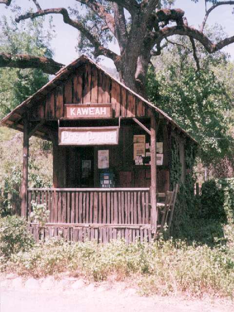
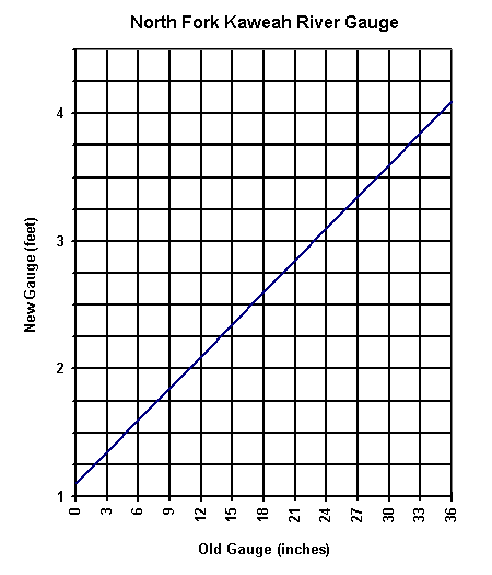
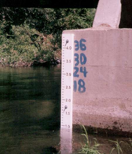
To get to the put-in cross the North Fork Bridge in the town of Three Rivers and drive 3.5 miles up North Fork Drive until the road crosses the river a quarter mile past the historic Kaweah Post Office. There is a new gauge on the left downstream side of the bridge footing (installed May 1997). A reading of 1.4 feet is a low water run at aprroximately 400 cfs. Above 2.5 feet this run will be cooking! The North Fork has been run as high as 3.0 ft. Continue on upstream 3.2 miles to Paradise Beach (BLM site). This is the take-out and is located where the road comes back down to the river level just before going uphill and away from the river for good. The put-in is another 5 miles upsteam. 4 miles upstream the road forks and the left fork goes through a gate and down to the river at the confluence with Yucca Creek. Just before the road splits there is a good view down into the canyon of the first big drop (Portage #1). It's best to run the North Fork with someone with previous North Fork experience. Plan on a very long day if it is your first descent without guidance from a boater with North Fork experience. Alot of the drops are semi blind from above. There are trees growing out of the river in some places. The overall character is pool drop but some of the continuous sections are quite long. The put-in is on Sequoia Park land and take-out is on BLM land, so, unlike the main Kaweah, there is no access problem. The road from the gate 0.8 miles above the put-in at Yucca Flat is closed by CDF after the start of fire season. This is not usually a problem unless it is a big water year and the North Fork is still running in summer (as was the case in 1998). It's a 20 minute walk to the river if the gate is closed. The author ran the North Fork 9 consecutive days in the summer of 1998 and has come to enjoy it immensely once the river was memorized.
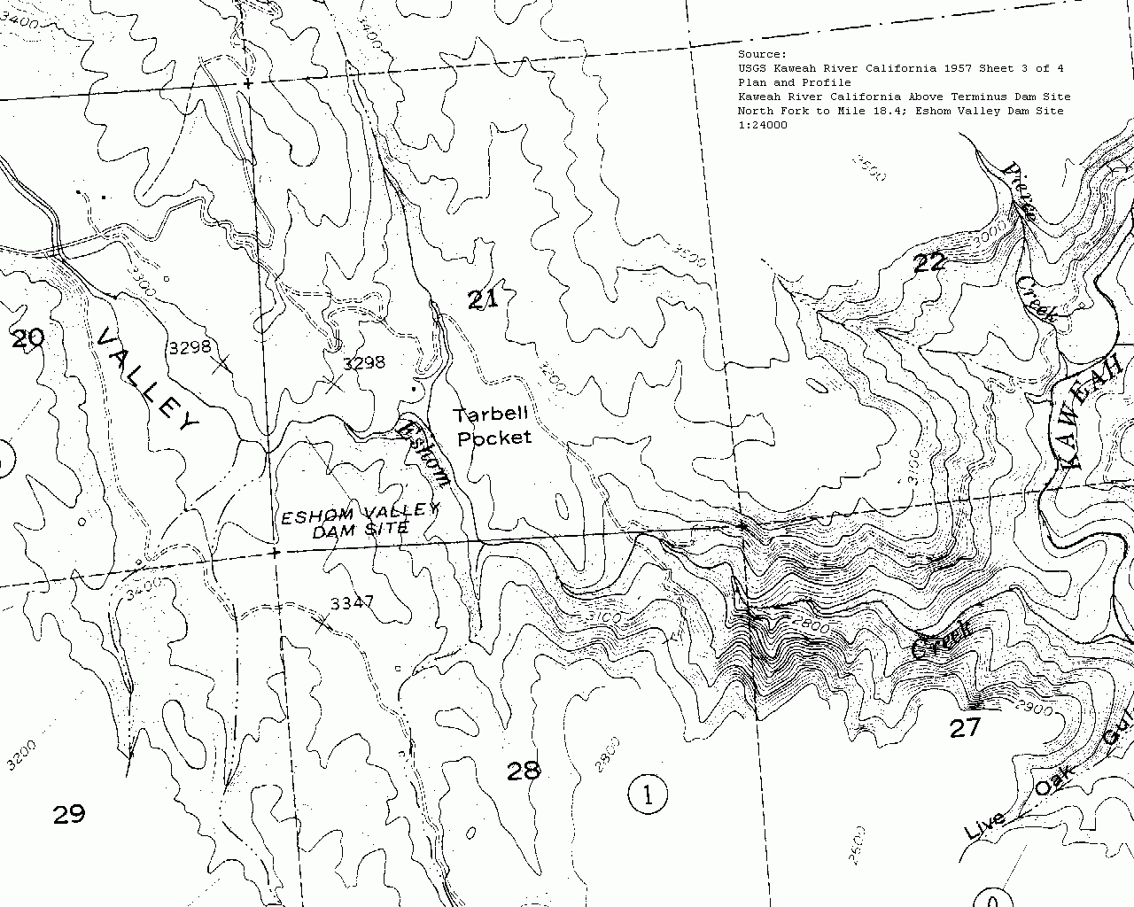
A bit of historic trivia. Back in 1957 when The Army Corps of Engineers was surveying for Terminus Dam near Lemon Cove they were also Surveying Eshom Valley for a Dam Site (click for map) at 3270 ft elevation. Since the North Fork Kaweah had alot of power potential the plan was to dam up and flood Eshom Valley with water diverted from the North Fork Kaweah via a tunnel. The North Fork and Eshom Creek would have been dewatered while generating power downstream somewhere, probably so far downstream as to ruin the North Fork for boating. Other additional dam sites were Dry Creek and the valley south of the Lemon Cove where water would be diverted from the Main Kaweah to increase the storage capacity of the Kaweah drainage.
RM 9.35 Put-In
Put in at the nice beach at the confluence with Yucca Creek
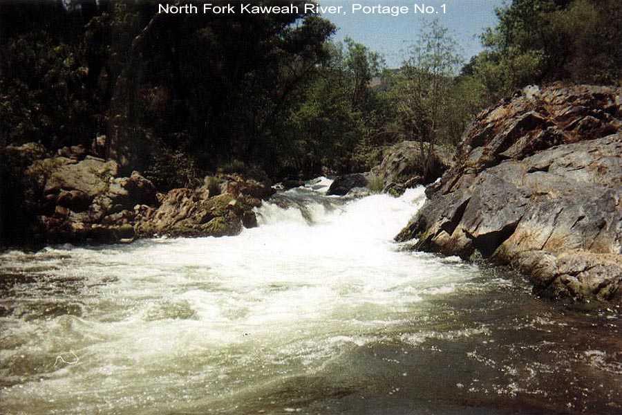 Portage No. 1
RM 8.9 Portage No. 1 (Class 5)
The left channel is the chicken route, the center channel is the hero route and the right channel is the warrior route. Better take a look at all the options before deciding. The rapid gets its name because it was usually portaged until a couple of years ago. The fold where the warrior route and hero route merge looks worse than it really is. The author started running the warrior route in 1998 and exited upside down half the time.
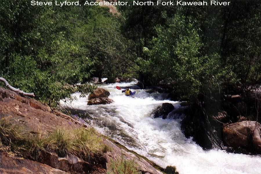 Accelerator
RM 8.7 Accelerator (Class 4+/5)
When the river disappears better get out and take a look at this one. It's long, steep, and fast. Plan your line through the first hydraulic to send your boat to the right channel. After this one critical move just hang on. There's a pool at the bottom to regroup before the next test immediately ahead.
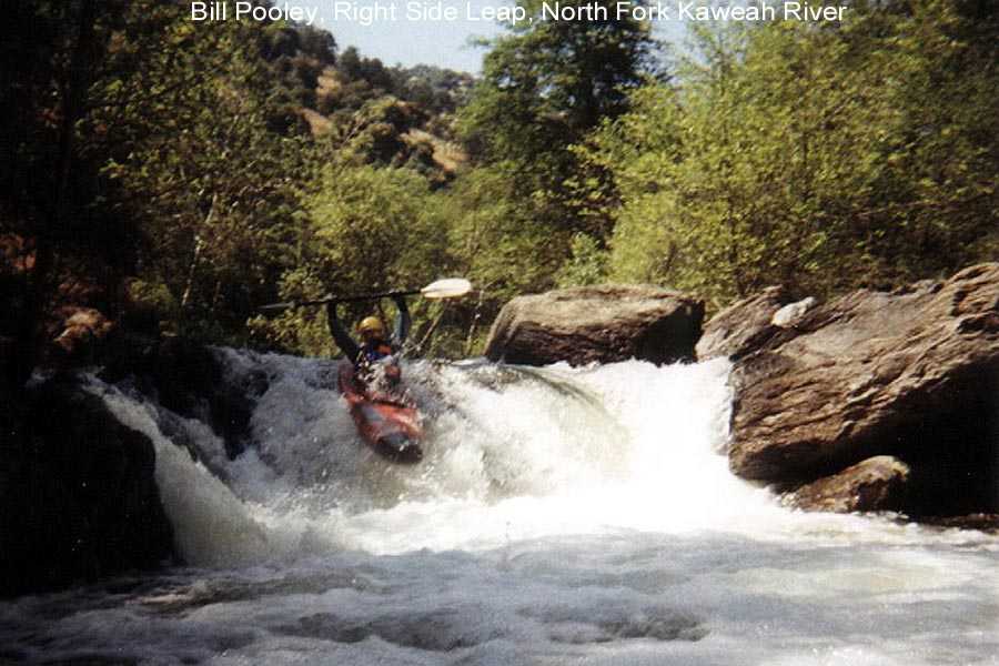 Right Side Leap
RM 8.6 Right Side Leap (Class 4)
The name says it all. At low water the current and rocks are trying to send you off the left side and down into a vertical pin situation. Please stay right as you run the 6 foot final plunge. The author has firsthand knowledge of the vertical pin possibilities and the difficulty of the extraction in the middle of the river.
RM 7.85-6.85
The river gets steep in this next one mile section and drops at an average of 180 feet/mile. This is the section from just upstream of Cherry Falls to below Diagonal. Looking back upstream from downstream of the major drops is breathtaking. The river is going downhill in a hurry.
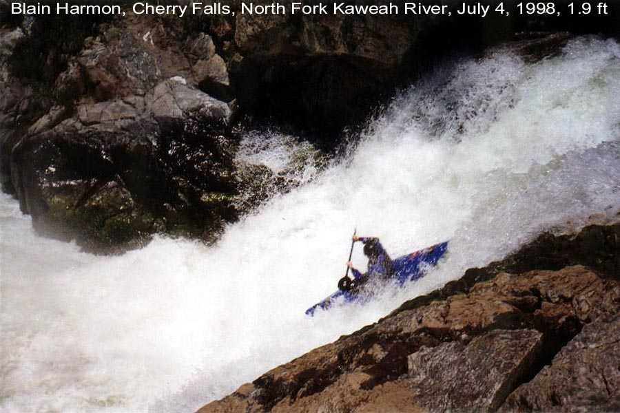 Cherry Falls
RM 7.5 CHERRY FALLS (Class 5+)
PORTAGE on the left. Identify the approaching falls by steep cliffs coming down to the river on the right. Do not boat beyond the take out eddy. Miss the eddy and you'll have to run the 25 foot falls (NOT RECOMMENDED). The portage is on very slippery granite. Be careful. The falls is being run more often now but it remains a serious drop. The river wide hydraulic 20 feet from the lip makes choosing a clean line off the lip very difficult.
Photos of the First descent of Cherry Falls in April 1997. Be sure to check this page out before you decide to run the falls too.
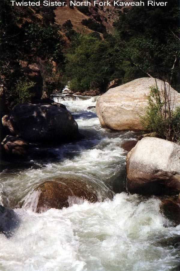 Twisted Sister
RM 7.6 Twisted Sister (Class 4+/5)
200 yards of action broken into 2 sections. There's a curling wave that is the crux to the upper section. Catch the eddy on the right half way down and then run the bottom half exiting on the LEFT side at the final drop. Pin rocks lurk on the right side.
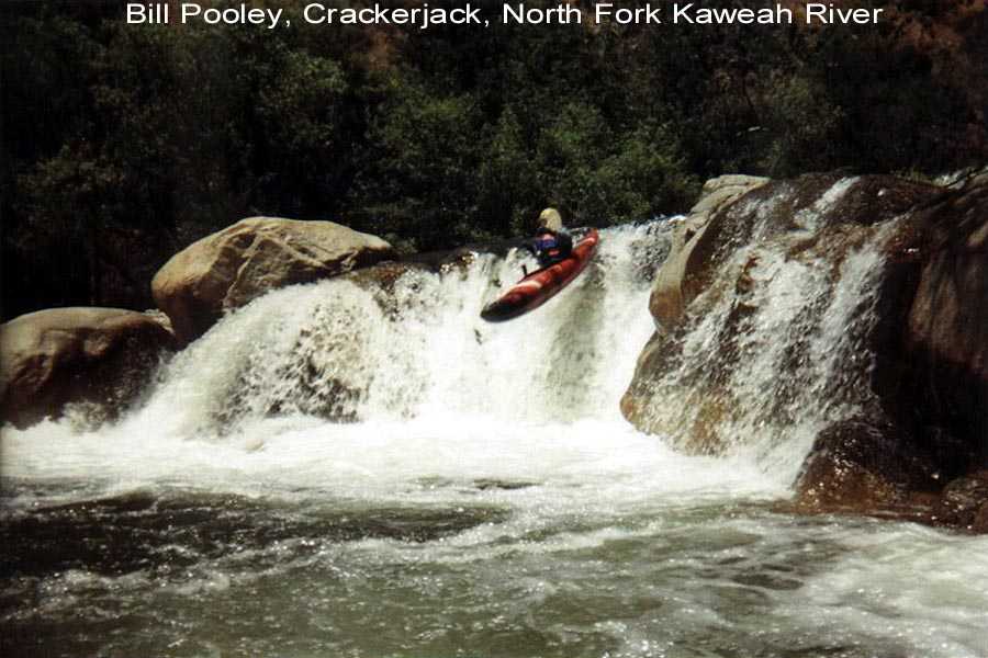 Crackerjack
RM 7.5 Crackerjack, Reach in and Find the Suprise (Class 4+)
The drop is formed by an old diversion dam. The old route is left center off a rock precepice while running to the left. A new (better) route has opened up at a new breach in the dam 10 feet left of the old route. Run the new route 10 degrees from right to left and you will avoid the "suprise". Boat scout the drop as best you can since there's no place to get out. Don't screw up, there's 200 yards of complex class 4+ whitewater following. There is another route on the far right that is also sometimes run. The land below Crackerjack is part of Trinity Ranch. Read on.
RM 7.2 Trinity Ranch is on left bank. Do not get out here and do not use the ranch access road for any reason. The landowners are not friendly to kayakers and hold a no trespassing attitude. Thier no trespassing viewpoint extends to the river itself. You have been warned.
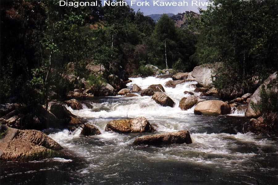 Diagonal
RM 6.9 Diagonal (Class 4+)
Scout left. Run from the right side eddy above the drop and try to make the turn back right at the bottom before the river stuffs you in the boulders on the left. More good whitewater follows.
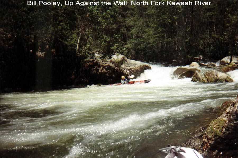 Hole in the Wall
RM 6.6 Hole in the Wall (aka Up Against the Wall) (Class 4+)
Possible Portage. A hard rapid to get out to scout. It's continuous class 3+ right into the final drop, a twisting left to right plunge into a pool up against the right wall. It's almost a guaranteed swim at greater than 1.6 ft on the gauge. The flood of '97 changed this drop from what used to be a final plunge into a tailstand to a now violent recirculating hole.RM 6.4 Advance Site
Two good drops followed by some nice continous rapids. This is a very nice alternate put-in when the gauge is a bit high for your tastes and you are planning to run to Bailey Bridge. Advance is a historic site of activity by the Kaweah Colonists who built the Colony Mill Road to Sequoia Park before the turn of the century in an attempt to log the giant sequoias in what is now Sequoia National Park. The colony went bust and the US government confiscated their road with no compensation.
RM 6.0 Blue Pool, a favorite summer swimming hole. The entrance into Chutes and Ladders is just downstream and is very hard to describe. Suffice it to say it is somewhat obscure.
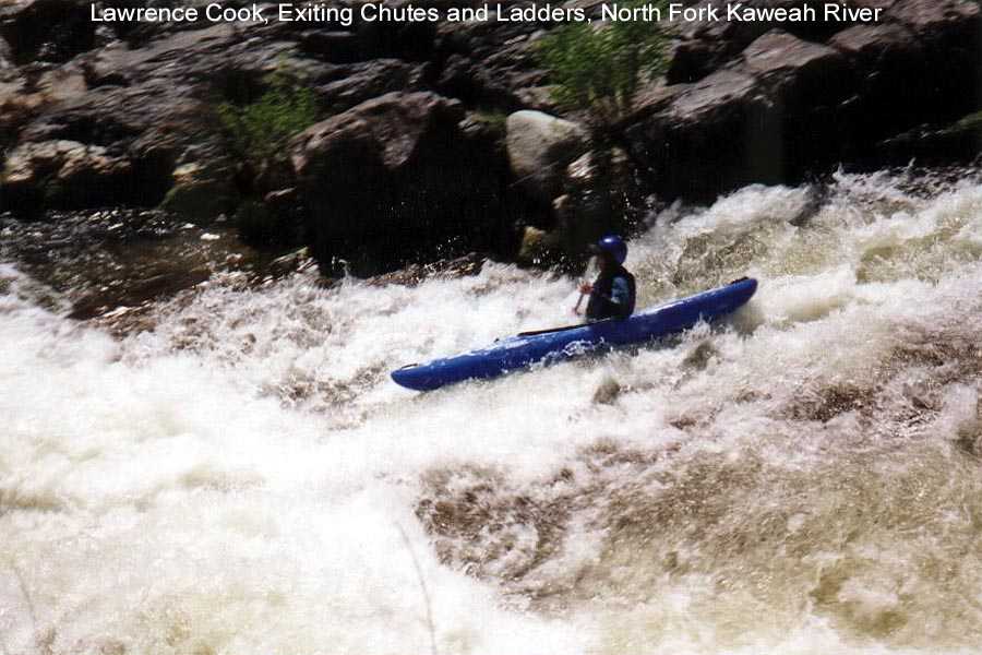 Chutes and
Ladders
Chutes and
Ladders
RM 5.9 Chutes and Ladders
A steep drop with a pinning rock on the left at low water. Better scout. The usual run is the right slot at the top of the drop and stay right below that. The hyraulic at the bottom will slow your recently aquired velocity.
RM 5.7 Paradise Beach Take out
Look upstream Above Yucca Creek (Class 5)
Continue downstream Paradise Beach to Bailey Bridge (Class 3+T/4)